Adventure School participates in the Amazon Services LLC Associates Program, an affiliate advertising program for sites to earn advertising fees by advertising and linking to amazon.com
John Burnside
“I went for a walk in the Arctic Circle without map or compass. Fortunately, I was only lost for hours, not days.”
This is the second part of a series. Go back and read part 1 if you missed it and you want to hear about my experience being lost. Then go read part 3 to learn about natural navigation techniques
How to read a map
Every good adventurer needs good map skills. Getting off the beaten path means knowing how to get back on the path when your adventure’s through.
Map reading is all about taking a 2D representation of the world around you and projecting a mental image in your mind and then connecting your mental image with reality. It requires understanding the basic components of a map:
The key
here’s a good example of USGS Topo symbols found in a key.

I often don’t consult the key until I’ve already started looking at a map and wonder what a feature is. When I have no idea what I’m looking at, I go down to the key to figure out that it’s mine tailings. After enough time with maps, you’ll get to know what all the symbols are without needing a key, but having it handy to make out odd features is super helpful when learning.
Colors
Colors are sometimes explained in the key, but not always. Here’s a list of standard colors used to represent various terrain and features.
- Black: Man-made or cultural feature, such as roads, buildings, names, boundaries, and transmission lines
- Blue: Water or hydrographic features, such as lakes, rivers, canals, glaciers, and swamps
- Brown: Contour lines, which we’ll get to in a bit
- Green/White: Landscape and vegetation cover. Green means there will be vegetation and white means open terrain
- Red: Important roads
- Yellow: secondary roads
Scale

The scale chart is important to understanding how big things are on the map. The most common scale used for back country navigation is the 1:24,000. That means that every one inch on the map equals 24,000 inches in real life.
Knowing the scale of your map is important so you know the distance from point A to point B. Notice, there’s typically a description of the scale of the contour lines on your map.
Contour lines
Contour lines make Topo maps different than other maps. they paint the 3D picture of the terrain onto a 2D surface. Knowing how to read the contours on your map is crucial to outdoor navigation with a map.

The distance between contour lines represents a defined elevation change. The lines have elevation markings on them that helps you know if the terrain is going up or down. The closer the lines are together, the steeper the terrain. To tell if you’re going into a huge pit or hiking up a big hill, you just have to look at the elevation numbers on the lines. If the outside ring says 10 and the inside ring says 40 that means you’re going up a hill that’s about 40 feet tall.
Use the contour lines to identify prominent landscape features like peaks, ridges, valleys, and canyons. After spending some time with a Topographic map, you’ll be able to quickly visualize the terrain using just the contour lines and other map features.
Shading
Pay particular attention to the various shades covering your map. in general, green means vegetation, and white means no vegetation but the shading can also indicate swamps, marshes, prairies, and
Using the map and the terrain to navigate
In many instances when you know pretty well where you’re at and the terrain includes prominent features, you can orient yourself to the map using only the map features and the natural terrain around you.
Here’s an example of orienting using the landscape:

This is a topographic map of Yankee Doodle Canyon outside of St. George, Utah. The top of the map is north. A canyoneering route runs through one of these canyons and abruptly back up the side of the canyon. If a person isn’t paying attention, they could miss the canyon and also easily miss the exit and end up with a long unplanned hike to get out of the canyon and back to the car.

So assume we drove on the road from the north and stopped after the stream crossing as indicated in our beta research. We know the parking spot is right after the stream and if we walk across the road to the south, we’ll find the head of the canyon.

This is what you’d see. The stream crossing is marked in blue. The canyon that isn’t really visible from the road is marked in red. Once you get out of the car and take a look at your map, you’ll be able to line it up using the road. Using the contour lines on the map, you can see that the canyon starts to the south and west of the stream crossing. The multiple footpaths leading through the brush are a good indication you’re in the right place, so walking down a path for fifty feet or so should lead you to the head of the
Sure enough, the map led you to downward sloping terrain that ended in the beginnings of the slot canyon. We didn’t need a compass for this, because the land provided orientation aids, but in flat areas or dense forests, or foggy days, a compass is an easy tool to find your bearings.
Okay, so I get the map. How do I use a compass with it?
The map alone is a great tool, but to really know where you’re at and where you’re headed, you need to orient the map. This requires knowing how to use a compass and having one with you.
Fortunately, a compass is on just about every packing list for outdoor adventures. Also fortunately, if you don’t already know how to use a compass, you’re in the right place to learn!

In the simplest terms, a compass allows you to line the map up with the terrain. You find north on the compass and point the map north so the 2D features match the real life features.
To do this you’ll want a relatively flat surface to put the map on. Put the compass on the map and wait for the arrow to point north. Then you’ll turn the map until the top (assuming your map has north at the top) of the map lines up with north on the compass.
A compass can sometimes be the only way to accurately find north in densely forested areas, open deserts, open water, or in thick fog so it’s an essential skill to learn.
Getting familiar with your compass
Many kinds of compasses exist. The most common ones used today are baseplate compasses.

Let’s get to know the basic parts of a baseplate compass.
Baseplate: Choose a compass with a clear baseplate. this allows you to see through to the map. A baseplate will typically also have a ruler on the edge to help measure distance as you triangulate positions or measure distances.
Direction of travel arrow: This arrow is just as described. It points in the direction of travel
Index line: this is a marking extending the direction of travel pointer to where you’ll be taking bearings from.
Rotating bezel: this is the circular gauge with degree markings on it from 0 to 360.
Magnetic needle: the magnetized spinning needle inside the bezel area. This needle will point to magnetic north, not true north.
Orienting lines: these help line the bezel up with the direction on the map
How to use a compass
We’ll now walk through several scenarios where your compass can come in handy. Read on to learn how to use a compass and be confident in your skills.
Be sure to read all the way to the end to learn about declination or you’ll end up heading toward magnetic north and not true north!
Finding your location with a compass
Using a compass and a map, you can find your location with a few simple steps.
Step 1: Orient your map

- Line up your compass bezel so the N aligns with the direction of travel arrow
- Place your map on a flat surface and place your compass on the map
- Turn your whole compass until the long edge is parallel to the map and the direction of travel arrow points to north on the map
- Turn the compass and map until the magnetic needle lines up with N on the bezel. Your map is now oriented to north
Step 2: Find a bearing from a landmark
- Choose a visible landmark that you can also identify on the map. Use lakes, mountains, canyons or trail features.
- Hold your compass out in front of you pointing directly at the landmark
- Rotate the bezel until the magnetic needle is pointing to N on the bezel
- Read the bearing aligned with the index line
Step 3: Transfer a bearing to the map

- Place your compass on the map so a corner near the direction of travel arrow touches the landmark for which you just read a bearing
- Rotate the entire compass so the orienting lines run north/south with the N on the bezel pointing toward north on the map
- Draw a line on the map along the straight edge of your compass
The line you drew will cross your general location. If you’re on a trail and there’s only one point along that line that crosses the trail, you know where you’re at. If you’re traveling cross country, you need more lines. Repeat the same process for one or two more visible landmarks. It’s best if they’re about 50 degrees apart from each other. This process is called triangulation.
After you’ve drawn three lines on your map from three separate landmarks, you’ll have something that looks like this:
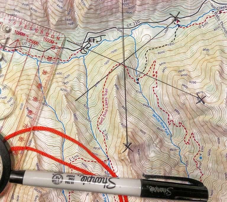
Notice the small triangle where the lines converge. The location within or very near this triangle shows your location. This is way cool! I love knowing that I can find my location if I have a few prominent landmarks to use. It definitely gives me confidence, but you have to know how to use a compass first!
Finding your direction with a compass
So what if you want to find which direction to travel to reach your destination? The process is similar but has a key few differences.
Step 1: Orient your map – this is the same as the steps described above
Step 2: Find the bearing to your destination
- Place your compass on the map with the long edge of the compass lining up between your location and your destination on the map
- Ensure the direction of travel arrow points in the direction of your destination
- Rotate the bezel so the orienting lines within the bezel area are aligned north/south
- Ensure the N on the bezel points to north on the map
- Read the bearing at the index line
Step 3: Use the bearing to navigate
- Hold the compass with the direction of travel arrow pointing away from you
- Turn yourself until the magnetic needle points to N on the bezel. The direction of travel arrow points you to your destination as long as the magnetic needle stays aligned with N
- Travel in the direction indicated by the direction of travel arrow until you arrive at your destination
What about declination?
So I mentioned earlier that if you want to know how to use a compass effectively you’ll need to account for declination.
What is declination you ask?
The earth has two north poles. One is the true north pole where Santa Clause lives. The other is the magnetic north pole. Magnetic north is what makes your compass to spin. The problem is that magnetic north isn’t in the same place as true north – and magnetic north moves around! Declination is the difference between true north and magnetic north.

This phenomenon creates a bit of a problem if you’re trying to find north, but never fear. There’s a solution for this debacle.
All topo maps come with a declination symbol that tells you the exact difference between true north and magnetic north. Declination changes with your location as well as over time, so be sure you have a current map or have looked up the current declination for your adventure.

You can look up current declination for any location at this NOAA website.
Some maps also have the rate and direction of declination change so you can calculate it yourself. Just don’t use a map that’s too old because the rate of declination change can vary over time.
How do I account for declination when navigating with a compass?
Some compasses are adjustable so you simply move the bearing from 0 degrees at N to whatever the declination is. For Utah, the declination is 11 degrees east of true north, so I’d adjust my compass 11 degrees to the east so N lines up with the 11 degree mark on the bezel
I don’t have an adjustable bezel, but there’s another way to account for declination. Some references will tell you to just add or subtract declination from true north to get your bearing, but that’s too much thinking for me when I’m navigating. I like to foolproof it by marking declination on my compass before I head out the door.
I use a fine point sharpie marker and a ruler to mark magnetic north right on the bezel of my compass.

If you mark your compass like this, all you have to do in all the steps above is use the sharpie N instead of the printed N everywhere N is used and you’ll head toward the correct true north and not magnetic north. No math required.
To reset your declination for a new trip in another location, simply wipe off the old mark with an alcohol swab or some white gas from your camp stove and redraw a new one.
Summary
So after reading this you may have a general understanding of how to use a compass, but to really be confident, you need practice.
I encourage you to save this page, print a map of a local area where you know your way around and feel confident you won’t get lost (I like to use Caltopo to print my maps).
Get a good compass if you don’t have one (
Go outside and practice! Pull up this article and walk through each of the exercises until you feel confident that you know how to use a compass. Next time you go on a hike or on an outdoor adventure take your map and compass and practice more in a less familiar environment.
All this practice will get you to the point that navigating with a compass and map will feel easy and you’ll not need to worry about losing your way any more as long as you prepare by packing a compass and map on your next adventure.
If you found this article useful, please pass it along to other adventurers so more people can be safe and confident in knowing how to use a compass and map.
Thank you, I appreciate your time here,
Chris


