Adventure School participates in the Amazon Services LLC Associates Program, an affiliate advertising program for sites to earn advertising fees by advertising and linking to amazon.com
“Complete freedom is not what a trail offers. Quite the opposite; a trail is a tactful reduction of options.”
― Robert Moor, On Trails: An Exploration
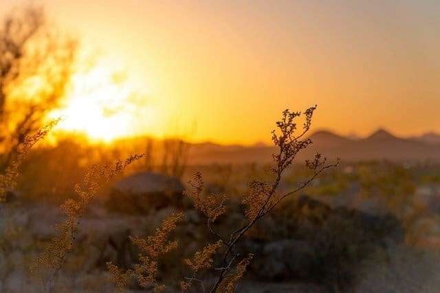
Backcountry navigation intimidates many adventurers, but knowing a few basics can mean the difference between an emergency bivouac and a hot shower. Having no compass, map, GPS, or trail signs, doesn’t mean you have to be lost.
To learn basic skills to avoid losing your way in the wild read this post (part 2)
To learn how to use a map and compass read this post (part 3).
Why do I need backcountry navigation skills?
I shouldn’t have to give my spiel about how unreliable technology can be and how you should have redundancies of critical components, but indulge me.
Phones break, get lost, run out of power, fail to get
Not only will natural navigation skills help you in dire straights, but will help you connect with nature and enjoy adventures more fully. Immersing yourself in your surroundings rather than your phone screen is just more enjoyable.
The basics
Natural navigation techniques are pretty simple when you understand nature. The problem is, most of us don’t understand nature very well. This post isn’t a lesson on all things natural navigation, but an intro to the essential skills you need to get home when things don’t go as planned.
A quick note for our southern hemisphere mates – flip north and south everywhere they’re used in this post and you’ll be all set.
The goal of backcountry navigation is to orient yourself to the landscape. That means identifying north, south, east, or west. Knowing your directions doesn’t mean you automatically know how to get home.
Getting home using a cardinal direction only works if you know where home is in relation to the direction. This requires having done your homework ahead of time and knowing the major terrain features such as uphill vs downhill to the car, trail, or nearest town.
Knowing you’re headed north will only take you to safety if you know where safety is in relation to north.
-
 The Natural Navigator$8.44

If you’re looking for more obscure and in-depth reading on natural navigation techniques, I highly recommend this book by Tristan Gooley. He’s the guru on natural navigation. Also, check out his website here.
For now, we’ll learn some basic natural navigation techniques.
Don’t get disoriented in the first place.
As you’re moving through backcountry environments, always stay alert and attentive to the signs around you. Don’t wait until you’re lost and confused before you start to think about where you are and where you’re headed.
An example is to pay attention to where the sun is rising as you start your day. Mentally note its location in relation to landmarks on the horizon that you can refer back to throughout the day.
Orient yourself to large landmarks such as peaks, rivers, canyons, or lakes and determine where they lie in relation to your destination. Orient yourself while you have your compass or GPS out, or before you even leave home.
Read about my basic navigation tips here and learn how to use a map and compass here.
Use handrails
Another natural backcountry navigation technique is a handrail. Not the type you find on the stairs at home, but a natural handrail. This could be natural features such as streams, cliff bands, the edges of forests, or coastlines. Many of these natural features form straight or relatively straight lines. You can use these lines or intersections of these lines as a handrail to guide your direction of travel. Learn more about handrails at this site.
Find as many clues as possible.
When navigating using nature, be sure to search for as many clues as you can. Each one will help, but may not be enough to reliably navigate by. When you add up 5, 8, or 10 data points, you can be much more confident in your direction. This isn’t as difficult when you’re continually on the lookout for clues and know what to look for.
So let’s finally jump into the good stuff…
Using the sun to navigate
I won’t waste your time with the history of solar navigation, but the sun has always been the first and most reliable natural navigation technique.
The sun as your compass
You can use the sun in numerous ways. The basics of solar navigation are knowing that the sun rises in the east and sets in the west. The exact path the sun traces through the sky varies through the year. In winter the sun starts in the east and goes far to the south before setting in the west. In the summer, the sun goes more straight across the sky. This also totally depends on your latitude. Being familiar with the path of the sun for the location of your adventure is important to using the sun reliably.
In the northern hemisphere, the sun will always be slightly south in the sky so depending on the time of day, and assuming the sun is visible, all you have to do is look up to know your directions. At midday, the sun will be due south and will move between ESE and WSW throughout the day.
Practice this wherever you are. Having a phone or compass or even street directions is a great way to quiz yourself quickly. Practicing when it isn’t critical is the key to being confident when it is critical.
Adding a watch adds accuracy
A simple observation of the sun is often enough accuracy to find your way, but using an analog wristwatch (or a watch face drawn on paper) can increase your accuracy.
If you lay your watch flat in front of you and point the hour hand directly toward the sun, you can accurately orient yourself. Line up your watch and then imagine a straight line between the tip of the hour hand and the 12:00 mark (1:00 during daylight savings time) to create a north-south line. North will be the side pointing away from the sun – remember, the sun is in the south. This is a cool little trick and if you don’t have an analog watch you can draw a watch face with an hour hand-drawn at the current time. You can also draw a clock face in the dirt or using some rocks.
What do you do on overcast days?
The sun can be used to navigate even on overcast days. The trick is to look for shadows. Even through the clouds, the sun’s light can shine bright enough to cast faint shadows. Sometimes it takes a bit of searching, but often you can see the shadows of trees or large rocks that will let you know where the sun is hiding behind the clouds.
Sometimes the clouds are thick enough that no shadows can be made out. On these days, you’ll need other natural navigation techniques up your sleeve.
Navigating using the wind
Knowing the direction of the prevailing wind can be as important as knowing where the sun will be in your locale. Research the prevailing winds before you head out into the bush but be warned that winds change with microclimates such as canyons, cliffs, and slopes. Open spaces not affected by terrain features will be the easiest to identify the wind direction.
If you can feel the wind blowing and you know it should be blowing to the northeast, you can use that as one data point among others. Wind can be a fickle thing so don’t rely on it alone.
Times when knowing the direction of the prevailing wind is more reliable is when you see its impact on the landscape. Trees are the most prominent feature to read the wind from. Look for leaning trees. If you see numerous trees all leaning in the same direction you can guess that the wind is the cause. Use this to orient yourself. You may not see the effects of the wind on the trees, but you can also look in the grass, sand, snow, or other vegetation.
Reading sand dunes and snowdrifts is a skill, but look for drifts to build up against the terrain with a sharp edge sort of like the crest of a wave toward the wind.
Plants
Plants can provide great navigational clues if you know how to find them. The breadth of information on this topic is too broad for a post like this, but here are some rules to get started with.
Moss is probably the most well-known natural navigation tool. Moss often dries up in direct sun unless it has a constant water source so moss tends to be found growing on the northern side of trees, rocks, and hills. If you can find it, moss can be a great clue.
Lichens are the opposite. They prefer more sun and are typically found on the south side of rocks.
Oftentimes trees, in their search for more sunlight, will grow more branches and leaves on the south side that gets more sun. This one can be a bit deceptive though because other events like avalanches, animal damage, or wind or weather exposure can influence this strongly and across a broad area. The message is that this technique can be helpful but isn’t often reliable.
When looking up at hills or bluffs, you can often see one slope that’s dry and brown and the opposite slope will be green or less brown. There may be different species of plants growing – some with more water needs than the opposite slope. The reason for this is mostly water. Water within the soil will last longer on the northern face than the southern and the plants will stay greener longer.
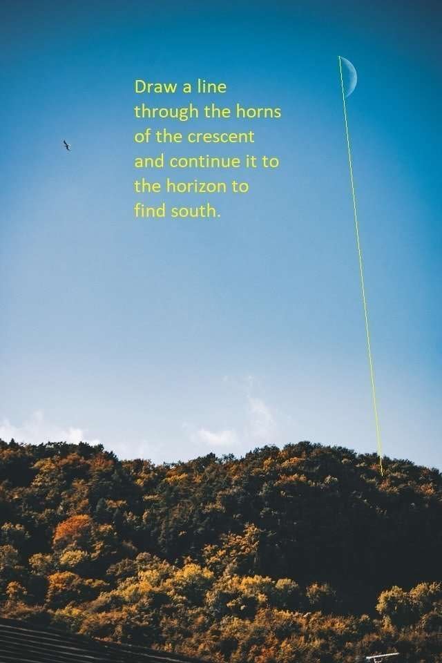
Navigating by moonl ight
The moon also rises and sets the same way as the sun from east to west, but the moon isn’t the same constant companion as the sun. The moon’s phases leave it more visible or less visible over the
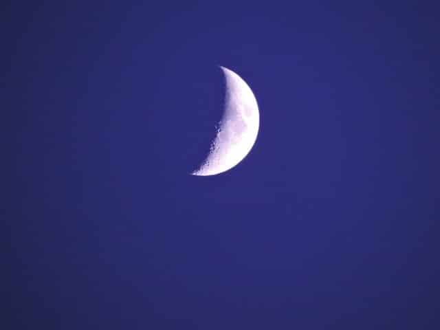
When the moon is in a crescent stage, there’s a trick that can be used with rough accuracy. It’s the crescent method and all you have to do is draw a line from the top horn through the bottom horn and straight down to the horizon. That intersection will be close to south.
Stars
On dark and moonless nights, the stars are great for navigating if they’re visible. Stars have been used for millennia for navigation, but it’s a dying skill. Learn more at this site.
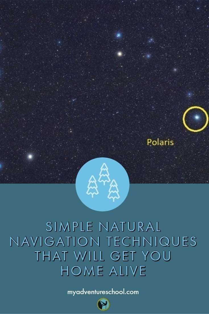
Polaris
In the northern hemisphere, you need to know how to find Polaris, the north star. If you can do that, you can find your way.
The north star isn’t at precisely north, but it’s close enough to be very useful as a natural navigation technique.
If you can find Urza Major or the big dipper, you can probably see the north star unless the sky is too polluted with other lights. You just follow the two stars that make up the outside edge of the big dipper’s dipper straight up until you see a bright star that makes up the tail of the little dipper. That’s Polaris. And that’s north.

While this method can be super handy when in open terrain, it can be tricky to actually follow the stars when they hide behind mountain peaks, cliff walls, or thick tree canopies.
The southern cross
So what about our friends in the southern hemisphere? Every technique in this post will work for you if you just replace north with south – except for finding the north star.
The north star is not visible in the southern hemisphere, but there is a constellation that is almost as easy to find and almost as constant – the southern cross
Finding the Southern Cross takes a bit more than looking to the New Zealand or Australian flags but it’s such a prominent and important feature of the southern night skies that it landed a spot on the flags of these countries.
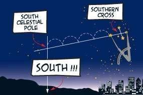
To find the southern cross, look for the four bright stars that line up in a cross shape. The horizontal or longer axis is the one you’ll use.
Draw a line about four times the distance of the space between the two points in the cross and then go straight down to the horizon and you’ll have a rough idea of where south is.
Using the snow to navigate
The primary way snow is used to navigate is by looking for patterns in the way it melts. Snow will melt faster on the south face of rocks, or on south-facing slopes because the sun sits in the southern sky relative to the snow. This is a very reliable indicator if you have enough data points to hone in on the most and least melted.
Be cautious of the melting snow due to other reasons such as black rocks underneath or running water.
Conclusion
I hope you never have to use any of these techniques because you’re legitimately lost, but I also hope you actively try to practice these techniques every chance you get.
Practicing these skills regularly helps me keep them sharp. I will sometimes pull out my compass just to verify I’m doing it right and give myself confidence for scenarios where it really matters.
Sometimes I get it wrong but when I don’t, I try to learn from the experience. I ask myself what assumptions I made that weren’t true or what I neglected to consider. With experience, you’ll gain confidence and be able to quickly pick up on clues all around you as you travel.
It’s an amazingly freeing feeling to be able to connect with nature in a way that removes the need for modern manmade technology. I encourage you to share your experiences with natural navigation techniques in the comments so we can all learn from each other and collectively improve our skills and confidence as we adventure.
Thank you for your support,
Chris